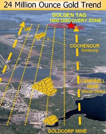
In 1995 the Company acquired a 100% interest in the McCuaig property, Dome Township, Red Lake,, Ontario from a local prospector. The property is favourably located at the junction of two major structures, namely the Cochenour-Gullrock Lake and Post Narrows deformation zones. The neighbouring Cochenour (1.2 million ounces), Campbell (10.2 million ounces) and the Goldcorp (3.5 million ounces) mines are all located along trend to the southeast within the Cochenor-Gullrock Lake zone. To date, mines situated on this trend have cumulatively produced over 15 million ounces of gold.
In December 1997, the Company entered into in an option agreement with Rubicon Minerals Corporation. Rubicon earned a 50% interest in the property by carrying out $450,000 in exploration work over 3 years. Rubicon earned an additional 10% interest in the property by spending $522,000 in drilling related expenditures in an April 2002 program.
Recent drilling on the property commenced in 2001, where Rubicon completed 1825 meters of drilling in 6 holes. Hole MC-01-02 yielded several anomalous gold assays, the best of which were 13.11 g/t Au (grams gold per tonne) over 0.30 meters and 7.45 g/t Au over 0.25 meters. In April 2002, Rubicon completed a 2nd phase 26 hole (6,347 meter) drill program of which 13 holes (2,926 meters) tested the gold-bearing structure first intersected in Hole MC-01-02 in 2001. The Highlight of the drill program include 75.91 g/t Au over 0.70 meters in hole MC-02-32, part of an interval grading 22.83 g/t Au over 3.1 meters. In winter 2003, a follow-up 10 hole 5,260 ft drill program was undertaken by the McCaig Joint Venture. Gold mineralization was intersected in a number of holes with the best intersection of 0.21 oz/ton over 1.97 feet (MC-03-45) and .18 oz/ton over 1.64 feet (MC-03-48). Several holes also intersected broad, lower grade gold zones. In winter 2004 a diamond drilling program consisting of 10 holes for a total of 1950 meters was completed. Holes 51 to 54 and 57 to 59 encountered strong silicification within ultramafic rocks over a horizontal distance of 300 meters. The best result was 19.1 g/t Au over 1.0 meters associated with a narrow 1cm thick quartz vein bearing significant visible gold in hole 53. In summer 2004, a program to evaluate target potential on the property, as well as a legal claim boundary survey to bring the claims to a mining lease was completed. No additional work has been planned for 2005.
This property, jointly held 50% by Freewest Resources Canada Inc., 30% by Golden Tag, and 20% by Gold Hawk Resources Inc., is located about 15 kilometres east of Lebel-Sur Quevillon, a small town along Route 133, approximately 160 kilometres northeast of Val D'or, Quebec. An extensive amount of surface exploration work followed by diamond drilling has been completed on the 44 claim property. The property, accessible by logging roads, contains the Toussaint Zone, which according to Freewest contains a calculated geological reserve of over 180,000 tons at over 7 g/t for contained gold of just over 43,000 ounces.
 Return to Golden Tag's Home